


What Is Bottom Towed Resistivity?
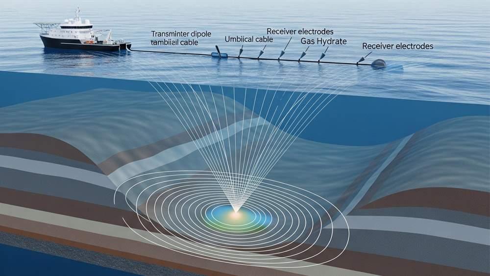
Bottom towed resistivity is a marine electromagnetic survey method used to measure the electrical resistivity distribution beneath the seabed. The technique typically uses a controlled electromagnetic source and receiver array towed close to the seafloor to investigate subseafloor resistivity variations.
The method is part of the broader family of marine controlled-source electromagnetic (CSEM) techniques, which are widely applied in offshore hydrocarbon exploration, gas hydrate research, and marine geological investigations.
Electrical resistivity in marine sediments depends on:
• pore fluid conductivity
• sediment porosity
• mineral composition
• temperature and salinity
Hydrocarbon-bearing formations and gas hydrate deposits usually show higher resistivity compared with surrounding seawater-saturated sediments. Therefore, resistivity measurements provide a complementary method to seismic surveys for identifying subsurface fluid distributions.
Bottom towed resistivity systems are designed to operate near the seabed, typically 5–50 m above the seafloor, allowing improved sensitivity to shallow subseafloor resistivity structures.
How Does Bottom Towed Resistivity Work?
Bottom towed resistivity surveys rely on controlled electromagnetic fields generated by a transmitter and recorded by receiver electrodes or magnetometers.
The basic acquisition system includes:
• electromagnetic transmitter dipole
• receiver electrode pairs or EM sensors
• towing cable and navigation system
• onboard recording and processing units
During the survey, the transmitter injects a time-varying electrical current into seawater through electrodes. This current generates an electromagnetic field that propagates through the conductive seawater and into the subseafloor.
The propagation of electromagnetic fields in conductive media follows Maxwell’s equations.
The relationship between electric field E, magnetic field B, and current density J is expressed as: ∇ × E = −∂B∂t and ∇ × B = μJ + με∂E∂t
where
• μ= magnetic permeability
• ϵ = dielectric permittivity
• J=σE(Ohm’s law)
The electrical conductivity σ is related to resistivity ρ by: ρ=1/σ
Variations in subsurface conductivity modify the electromagnetic signal measured by the receivers. By inverting the recorded data, geophysicists estimate the resistivity structure beneath the seabed.
What Are the Typical System Parameters for Bottom Towed Resistivity Surveys?
The performance of a bottom towed resistivity system depends on transmitter strength, receiver spacing, and survey geometry.
Typical survey parameters include:
| Parameter | Typical Range |
| Transmitter dipole length | 50–300 m |
| Source current | 100–1500 A |
| Operating frequency | 0.1–10 Hz |
| Receiver spacing | 10–100 m |
| Tow height above seabed | 5–50 m |
| Investigation depth | 50–1000 m below seabed |
Low frequencies are commonly used because electromagnetic fields penetrate deeper into conductive marine sediments.
The skin depth δ describes the penetration depth of electromagnetic signals: δ = √2μσω
where
• ω = angular frequency
• σ = electrical conductivity
• μ = magnetic permeability
Lower frequencies and lower conductivity environments increase investigation depth.
Why Is Electrical Resistivity Important in Marine Geophysical Exploration?
Electrical resistivity provides information about subsurface fluid content and lithology that cannot always be resolved from seismic data alone.
Typical resistivity ranges in marine environments are:
| Material | Resistivity (Ω·m) |
| Seawater | ~0.3 |
| Clay-rich sediments | 1–5 |
| Water-saturated sandstone | 1–10 |
| Hydrocarbon-bearing sandstone | 20–100 |
| Gas hydrate sediments | 10–200 |
Because hydrocarbons replace conductive brine in pore spaces, resistivity increases significantly in reservoir formations. Marine electromagnetic methods therefore help distinguish between water-filled and hydrocarbon-filled reservoirs.
What Are the Main Applications of Bottom Towed Resistivity Surveys?
Bottom towed resistivity surveys support several offshore exploration and research activities.
Hydrocarbon Reservoir Detection
Marine CSEM surveys help identify resistive anomalies that may correspond to hydrocarbon accumulations beneath the seabed. When integrated with seismic reflection data, resistivity measurements reduce uncertainty in reservoir characterization.
Several offshore exploration projects have demonstrated the value of marine CSEM in identifying resistive targets associated with hydrocarbon-bearing formations.
Gas Hydrate Exploration
Gas hydrates are crystalline structures composed of methane molecules trapped within water ice lattices. Hydrate-bearing sediments often exhibit higher resistivity compared with surrounding sediments.
Marine electromagnetic surveys have been used successfully to map hydrate deposits along continental margins such as the Nyegga region offshore Norway. High-resolution resistivity imaging from marine CSEM surveys has revealed hydrate pipes and resistive sediment layers beneath the seabed.
Subsea Freshwater Detection
Marine resistivity surveys have been used to detect freshwater reservoirs trapped beneath the seafloor. Freshwater has significantly lower electrical conductivity than seawater, producing measurable resistivity contrasts.
Such discoveries have been reported along continental shelves and coastal aquifers.
Environmental Monitoring and CO₂ Storage
Electromagnetic methods also support monitoring of subseafloor carbon storage sites. Resistivity changes may indicate migration of injected CO₂ or changes in pore fluid saturation.
What Are the Advantages of Bottom Towed Resistivity Systems?
• Continuous Coverage: The towed system records electromagnetic data continuously along the survey line, producing dense spatial sampling.
• High Survey Efficiency: Large offshore areas can be surveyed without deploying and recovering seabed instruments.
• Sensitivity to Shallow Structures: Operating close to the seabed improves detection of resistivity variations in shallow sediments.
• Seismic Integration: Electromagnetic data can be interpreted together with seismic datasets to improve subsurface characterization.
What Is an Example of Bottom Towed Resistivity in Offshore Exploration?
A well-known example comes from the Nyegga gas hydrate province offshore Norway.
Researchers conducted marine CSEM surveys using both towed and seabed receivers to image resistive structures associated with gas hydrate accumulations.
The survey revealed:
• resistive hydrate pipes beneath the seabed
• vertical fluid migration pathways
• hydrate-bearing sediment layers
The results demonstrated that marine electromagnetic techniques can resolve hydrate-related resistivity anomalies at high resolution.
Sum up
Bottom towed resistivity surveys provide an effective approach for investigating subseafloor electrical properties in marine environments. By transmitting controlled electromagnetic signals and measuring their response near the seabed, the method enables high-resolution imaging of resistivity variations in shallow marine sediments.
Compared with stationary seabed receiver systems, bottom-towed configurations allow continuous data acquisition along survey lines and improved spatial coverage. When combined with seismic reflection data and advanced electromagnetic inversion algorithms, bottom towed resistivity surveys contribute to a more comprehensive understanding of subseafloor structures and fluid distributions.
Related Products
Resistivity Cable for Marine and Borehole Well: https://www.seis-tech.com/marine-resistivity-cable/
References
Constable, S., & Srnka, L. J. (2007). An introduction to marine controlled-source electromagnetic methods for hydrocarbon exploration. https://doi.org/10.1190/1.2432483
Cox, C. S., Constable, S. C., Chave, A. D., & Webb, S. C. (1986). Controlled-source electromagnetic sounding of the oceanic lithosphere. https://doi.org/10.1038/320052a0
Edwards, R. N. (1997). Resource evaluation of marine gas hydrates using seafloor transient electric dipole methods.
Ellingsrud, S. et al. (2002). Remote sensing of hydrocarbon layers by seabed logging.The Leading Edge.
Key, K. (2012). Marine electromagnetic studies of seafloor resources and tectonics.Surveys in Geophysics.
Gribenko, A., & Zhdanov, M. (2007). Rigorous 3D inversion of marine CSEM data.
Streich, R. (2016). Controlled-source electromagnetic approaches for hydrocarbon exploration.Surveys in Geophysics.


