


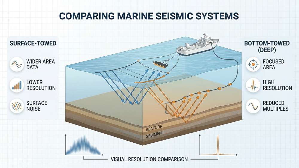
What Is Bottom Towed Seismic?
Bottom-towed seismic, often referred to as ocean-bottom cable (OBC), ocean-bottom node (OBN), or deep-towed seismic acquisition, is a marine seismic survey configuration in which seismic receivers are deployed on or near the seafloor rather than towed at the sea surface.
In these systems, arrays of hydrophones and geophones record acoustic waves generated by controlled seismic sources such as air guns, sparkers, or boomers. Because the receivers operate close to the seabed, bottom-towed seismic systems provide improved signal quality and allow more accurate imaging of subseafloor structures.
Compared with conventional surface-towed streamer surveys, bottom-towed seismic acquisition reduces the influence of surface-related multiples and water-column noise. The technique is widely used in deep-water hydrocarbon exploration, subsea infrastructure surveys, and marine geohazard investigations.
How Does Bottom Towed Seismic Acquisition Work?
Marine seismic surveys rely on acoustic wave propagation through seawater and subsurface sediments. A seismic source generates acoustic energy that travels downward through the water column and into the seabed. When the wave encounters a boundary between layers with different physical properties, part of the energy is reflected back toward the receivers.
The reflection strength depends on the acoustic impedance contrast between geological layers.
Acoustic impedance is defined as Z=ρV
where
• ρ = density of the medium
• V = seismic wave velocity
The reflection coefficient at an interface between two layers is R = Z2 – Z1Z2 + Z1
where
• Z1 and Z2 are the acoustic impedance values of the two layers.
Seismic receivers deployed on or near the seabed measure the reflected wavefield. These data are then processed using seismic imaging algorithms to generate detailed subsurface profiles.
What Are the Typical Survey Geometry Parameters?
The acquisition geometry of bottom-towed seismic surveys is designed to optimize signal quality and spatial resolution for subseafloor imaging.
Typical survey parameters include:
| Parameter | Typical Range |
| Tow height above seabed | 5–50 m |
| Source type | air gun, sparker, boomer |
| Dominant frequency | 20–1000 Hz |
| Receiver spacing | 6.25–25 m |
| Survey speed | 3–5 knots |
| Investigation depth | 50–2000 m below seabed |
Lower frequency sources provide deeper penetration, while higher frequency sources provide higher vertical resolution.
The vertical resolution of seismic imaging can be approximated by Δz = V4f
Where
• V = seismic velocity
• f = dominant frequency
What Are the Advantages of Bottom Towed Seismic Systems?
Bottom-towed seismic acquisition provides several advantages compared with conventional streamer surveys.
Reduced Water-Column Multiples
Receivers located near the seabed reduce interference from reflections between the sea surface and seabed.
Improved Signal-to-Noise Ratio
Shorter propagation paths between the seabed and receivers increase signal strength.
Multi-Component Recording
Ocean-bottom systems often record both pressure and particle motion, allowing acquisition of converted-wave (PS-wave) data.
Imaging Beneath Complex Overburden
Bottom-towed systems improve seismic imaging beneath structures such as salt bodies, gas clouds, or complex sediment layers.
How Do OBC, OBN, and Streamer Seismic Systems Compare?
Different marine seismic acquisition systems provide different advantages depending on survey objectives.
| Method | Receiver Location | Data Type | Typical Applications |
| Streamer seismic | towed near sea surface | pressure (P-wave) | regional exploration |
| Ocean-bottom cable (OBC) | cable deployed on seabed | multi-component | reservoir imaging |
| Ocean-bottom node (OBN) | autonomous seabed sensors | multi-component | complex geology imaging |
| Deep-towed seismic | sensors towed near seabed | high-resolution imaging | shallow surveys |
Streamer systems are efficient for large regional surveys, while OBC and OBN systems provide higher data quality in complex geological environments.
Why Is Bottom Towed Seismic Useful for Geohazard and Engineering Surveys?
Bottom-towed seismic systems are frequently used in offshore engineering projects and marine geological studies.
Applications include:
• mapping shallow faults
• detecting gas pockets
• imaging buried channels
• identifying submarine landslides
• investigating gas hydrate structures
Because the sensors operate near the seabed, the method provides high-resolution imaging of shallow sediment layers that may pose risks to offshore infrastructure.
Conclusion
Bottom-towed seismic acquisition provides a high-resolution method for imaging subseafloor geological structures in marine environments. By placing seismic receivers on or near the seabed, the technique improves signal quality and reduces interference from water-column noise and surface multiples.
The method is widely used in offshore exploration, marine geohazard investigations, and subsea engineering surveys. When integrated with other geophysical techniques such as marine electromagnetic surveys, bottom-towed seismic data contribute to a more comprehensive understanding of subsurface structures and fluid distributions.
Related Products
* Hydrophone Cable Streamers: https://www.seis-tech.com/12-24-48-channel-hydrophone-cable-streamer/
References
Dean, T., et al. (2016). Ocean-bottom seismic acquisition in the North Sea: Technology and applications.First Break.
Santos, M., & Rietveld, W. (2018). Ocean-bottom node seismic: Advances in acquisition and processing.The Leading Edge.
Moldoveanu, N., et al. (2019). Marine seismic acquisition using ocean-bottom nodes: Technology and applications.
Halliday, D., et al. (2020). Ocean-bottom seismic methods for imaging complex subsurface structures.Geophysical Prospecting.
Szydlik, T., et al. (2021). High-resolution ocean-bottom seismic acquisition and imaging in deep-water environments.


