


No, Bottom-Towed Seismic and Bottom-Towed Resistivity are not the same thing. They are both marine geophysical methods used to explore subseafloor structures, but they rely on fundamentally different physical principles, equipment, and data interpretations. While both techniques are used for offshore exploration, they measure distinct properties of the subsurface and serve different purposes.
What Is Bottom-Towed Seismic?
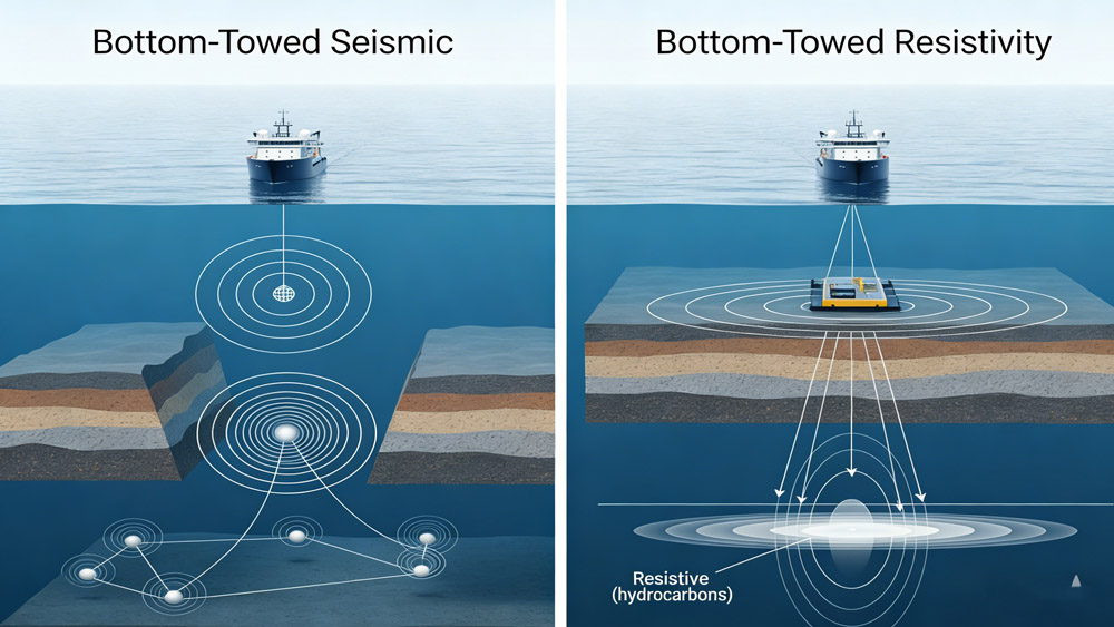
Bottom-towed seismic, also referred to as Ocean-Bottom Cable (OBC) or Ocean-Bottom Node (OBN) seismic, involves deploying seismic sensors (hydrophones or geophones) on or near the seabed. A seismic source, such as an air gun or sparker, generates acoustic waves that propagate through the water and into the seabed. The sensors record the reflected seismic waves as they bounce off geological layers beneath the seafloor.
The technique is primarily used to:
• Map geological structures such as faults, layers, and horizons
• Characterize subsurface rock properties
• Detect gas hydrate accumulations and subsurface fluid reservoirs
• Assess geohazards like shallow gas pockets and buried channels
The key advantage of bottom-towed seismic is the improved signal-to-noise ratio and better resolution for subsurface imaging compared to conventional surface-towed seismic. It reduces noise from the water column, providing clearer and more reliable data for geotechnical and hydrocarbon exploration.
What Is Bottom-Towed Resistivity?
Bottom-towed resistivity, often referred to as marine controlled-source electromagnetic (CSEM) surveys, involves measuring the electrical resistivity of the seabed and subseafloor formations.
The technique uses an electromagnetic transmitter and receivers deployed on or near the seafloor. The transmitter sends out controlled electromagnetic waves, which interact with the underlying sediments and formations. The receivers measure how these waves change as they pass through resistive or conductive materials in the subsurface.
Bottom-towed resistivity surveys are used to:
• Detect hydrocarbonsor gas hydrates based on the resistivity contrasts between hydrocarbon-bearing sediments and surrounding water-saturated layers
• Map subseafloor fluid distributionsand hydrological properties
• Identify geothermal energy reservoirsor freshwater aquifers under the seabed
• Monitor CO₂ sequestrationin deepwater storage sites
The primary advantage of bottom-towed resistivity is its ability to detect fluid-related anomalies and provide a detailed picture of subsurface fluid saturation.
How Are Bottom-Towed Seismic and Bottom-Towed Resistivity Different?
| Feature | Bottom-Towed Seismic | Bottom-Towed Resistivity |
| Measured Property | Acoustic impedance (density * seismic velocity) | Electrical resistivity (inverse of conductivity) |
| Primary Data Type | Seismic reflections | Electromagnetic field interaction |
| Equipment | Seismic sources (air guns, sparkers), hydrophones/geophones | Electromagnetic transmitters, resistivity receivers (electrodes) |
| Main Application | Geological structure imaging, fault detection, subsurface mapping | Fluid content detection, hydrocarbon & gas hydrate exploration, groundwater mapping |
| Signal Type | Acoustic waves (pressure and shear waves) | Electromagnetic waves (low-frequency) |
| Resolution | High resolution for shallow subsurface structures | High sensitivity to fluid distribution and resistive anomalies |
Can They Be Used Together?
Yes, Bottom-Towed Seismic and Bottom-Towed Resistivity methods are often complementary and are frequently combined to provide a more comprehensive understanding of the subsurface.
For instance:
• Seismic surveys give detailed images of subsurface structural features (e.g., faults, layers), but they do not directly provide information on fluid content.
• Resistivity surveys provide valuable data about fluid distribution, allowing for the detection of hydrocarbon reservoirs, gas hydrates, or freshwater beneath the seabed. However, they do not offer the same level of detail regarding structural mapping.
Using both methods together improves the overall interpretation of the subsurface by allowing for both structural and fluid-related properties to be analyzed simultaneously.
How Do These Methods Differ in Practice?
In practical terms, these two methods are applied to different aspects of offshore exploration:
Bottom-Towed Seismic is often used for imaging complex geological formations, assessing geohazards, and characterizing subsurface rock properties. For example, during an offshore survey in the North Sea, a bottom-towed seismic survey was conducted to image shallow gas pockets and other potential geohazards before drilling.
Bottom-Towed Resistivity is typically used for detecting hydrocarbons or gas hydrates. For instance, a marine CSEM survey might be used to locate gas hydrate accumulations in the North Atlantic by identifying high resistivity anomalies beneath the seafloor.
Which Method Is Better for Specific Subsurface Targets?
1. Hydrocarbon Detection
• Bottom-Towed Seismic: Excellent for identifying structural traps and faults.
• Bottom-Towed Resistivity: Ideal for detecting hydrocarbon-bearing formations based on resistivity contrasts with surrounding water-saturated sediments.
2. Gas Hydrate Exploration
• Bottom-Towed Seismic: Identifies gas hydrate pipes and bottom-simulating reflectors (BSRs).
• Bottom-Towed Resistivity: Detects gas hydrate by identifying high resistivity zones in the sediment layers.
3. Shallow Geological Mapping
• Bottom-Towed Seismic: Provides detailed imaging of shallow subsurface structures (e.g., buried channels, faults).
• Bottom-Towed Resistivity: Can map fluid distribution and freshwater aquifers beneath the seabed.
Conclusion
Bottom-Towed Seismic and Bottom-Towed Resistivity are distinct methods that offer complementary insights into the subsurface structure and fluid distribution. While bottom-towed seismic surveys excel at imaging geological features and structural formations, bottom-towed resistivity surveys are more effective in identifying fluid-related anomalies such as hydrocarbons, gas hydrates, and groundwater.
By combining both methods, geophysicists can gain a more comprehensive understanding of subsurface conditions, allowing for more accurate assessments in offshore exploration, geohazard monitoring, and resource mapping.
Related Products
* Hydrophone Cable Streamers: https://www.seis-tech.com/12-24-48-channel-hydrophone-cable-streamer/
* Resistivity Cable for Marine and Borehole Well: https://www.seis-tech.com/marine-resistivity-cable/
References
Dean, T., et al. (2016). Ocean-bottom seismic acquisition in the North Sea: Technology and applications.First Break, 34(10), 63–70.
Santos, M., & Rietveld, W. (2018). Ocean-bottom node seismic: Advances in acquisition and processing.The Leading Edge, 37(12), 896–902.
Moldoveanu, N., et al. (2019). Marine seismic acquisition using ocean-bottom nodes: Technology and applications.Geophysics, 84(6), IM37–IM48.
Halliday, D., et al. (2020). Ocean-bottom seismic methods for imaging complex subsurface structures.Geophysical Prospecting, 68(5), 1502–1518.
Szydlik, T., et al. (2021). High-resolution ocean-bottom seismic acquisition and imaging in deep-water environments. Geophysics, 86(3), WA101–WA112.


